LTSER-platform Veluwe

Facility
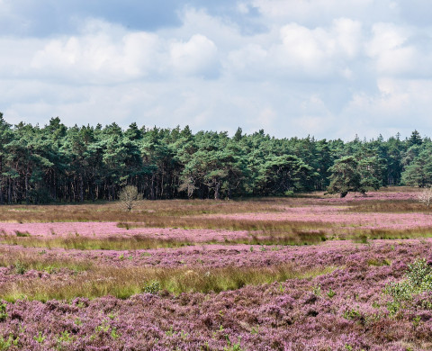
The area defined as ‘the Veluwe’ lies in the province of Gelderland, the Netherlands, West of the river IJssel and North of the river Rhine. The region hosts the largest connected nature area of the country. The natural landscape consists of a mix of forests, heathlands, sand drifts, lakes, and moorlands and is surrounded by agriculture, settlements, or infrastructure. This means there is a lot of interaction between humans and nature.
View all facilities on the map
Tongerense Heide

Details

Infrastructure type
Field sites / Long-term monitoring
Landscape type
Research partner
Radboud University
NIOO-KNAW

Study site

The area defined as ‘the Veluwe’ lies in the province of Gelderland, the Netherlands, West of the river IJssel and North of the river Rhine. The region hosts the largest connected nature area of the country. The natural landscape consists of a mix of forests, heathlands, sand drifts, lakes, and moorlands and is surrounded by agriculture, settlements, or infrastructure. This means there is a lot of interaction between humans and nature. 

The unique circumstances of highly populated areas, combined with nature, provide great opportunities for research on the varied interactions between nature and humans to be carried out. A great array of different ecological and socio-economic research has already been carried out in the Veluwe, which makes it a good quality LTSER (Long-Term Socio-Ecological Research) platform. 


Research topics 

  • Biodiversity (vegetation, fungi, algae, birds, mammals, amphibians, fishes, arthropods)  
  • Weather and climate 
  • Deposition and pollution 
  • Socio-economic data 


References 

Boonman-Berson, S., Driessen, C., Turnhout, E. (2019). Managing wild minds: From control by numbers to a multinatural approach in wild boar management in the Veluwe, the Netherlands. Transactions of the Institute of British Geography 44:2–15. 

Limpens, J., Tomassen, H.B.M., Berendese, F. (2003). Expansion of Sphagnum fallax in bogs: striking the balance between N and P availability. Journal of Bryology 25: 83-90. 

Siepel, H., Bobbink, R., van de Riet, B.P., van den Burg, A.B., Jongejans, E. (2019). Long-term effects of liming on soil physico-chemical properties and micro-arthropod communities in Scotch pine forest. Biology and Fertility of Soils 55. 675-683. doi: 10.1007/s00374-019-01378-3 

Sparrius, L. (2011). Inland dunes in the Netherlands: soil, vegetation, nitrogen deposition and invasive species. Dissertation University of Amsterdam 165 pp. http://dare.uva.nl/record/391151  

Vogels, J.J., Weijters, M.J., Bobbink, R., Bijlsma, R.-J., Lamers, L.P.M., Verberk, W.C.E.P., Siepel, H. (2019). Barriers to restoration: Soil acidity and phosphorus limitation constrain recovery of heathland plant communities after sod cutting. Applied Vegetation Science 23. 94-106. doi: 10.111/avsv.12471 

van Eekeren, N., Jongejans, E., van Agtmaal, M., Guo, Y., van der Velden, M., Versteeg, C., Siepel, H. (2022). Microarthropod communities and their ecosystem services restore when permanent grassland with mowing or low-intensity grazing is installed. Agriculture, Ecosystems and Environment 323. 107682. doi:10.1016/j.agee.2021.107682 

Van der Heide, C.M., Van den Bergh, J.C.J.M., Van Ierland, E.C., Nunes, P.A.L.D. (2008). Economic valuation of habitat defragmentation: A study of the Veluwe, the Netherlands. Ecological economics 67:205-216. 

Vink, H., Schröder, J. (2021). Decline of the number of occupied badger (Meles meles) setts in the Veluwe region (the Netherlands) and its possible causes. Lutra 64: 5-18. 


Running period 

1930-present 

Equipment/facilities 

The research infrastructure is very diverse: complete meteorological observation sites, a vast network of piezometers, several visitor centres with expositions and research results, etc. The infrastructure is also very diversely owned, from universities to nature management organisations, waterboards and province. However, there is no central building at the 'site'.  

The information on LTSER-platform Veluwe is registered in DEIMS-SDR (Dynamic Ecological Information Management System - Site and dataset registry). DEIMS-SDR is an information management system that allows discovery of long-term ecosystem research sites around the globe, along with the data gathered at those sites and the people and networks associated with them. For the Veluwe there are currently no datasets directly accessible via DEIMS.  

Data management 

When datasets are used the following applies:  

  • Co-authorship of the data provider on publications resulting from use of the dataset. 
  • The opportunity for the data provider to collaborate on the project using the dataset. 
  • Reprints of articles using the dataset must be provided to the data provider. 
  • Mutual agreement on reciprocal sharing of data. 

Available datasets 

Soil 

  • Topography 
  • Soil physics 
  • Soil chemistry 

Water 

  • Water quality 
  • Sub-surface water 
  • Surface water 

Atmosphere 

  • Air quality 
  • N deposition 

Biodiversity 

  • Plants 
  • Animals 

Population dynamics 

  • Plant dynamics 
  • Animal dynamics 
  • Animal movement 

Land use  

  • Land use maps 
  • Urbanization 
  • Agriculture 
  • Nature type 
  • Infrastructure 
  • Habitat fragmentation 
  • Nature areas 
  • Nature management 

Conditions for access 

Access to the area for research purposes should be requested from its managers: Staatsbosbeheer, Natuurmonumenten, National Park De Hoge Veluwe, Gelders Landschap en Kastelen, or Royal Domains. 

When interested in accessing a specific dataset, please content Prof. Henk Siepel who can further inform you about the instructions and conditions for access to specific datasets.  

Details

Infrastructure type
Field sites / Long-term monitoring
Landscape type
Research partner
Radboud University
NIOO-KNAW

Location

52°14'18.6"N 5°49'43.7"E
View on Google Maps