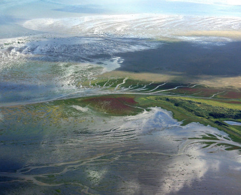
LTSER-platform Dutch Wadden Sea

Details
- Infrastructure type
- Field sites / Long-term monitoring
- Research partner
The facility
The Long-Term Socio-Ecological research platform Dutch Wadden Sea area is a large coastal area (615510 ha) bordering the north of the Netherlands. A range of inhabited barrier islands (included in the LTSER Dutch Wadden Sea Area) separate the Dutch Wadden Sea from the North Sea. The barrier islands comprise sandy beaches, dunes, grazed and ungrazed saltmarsh areas, and polders with meadows and villages. The Dutch Wadden Sea itself consists of intertidal mudflats, sandbars and subtidal areas. The southern border of the area consists of saltmarshes bordering inhabited polders, many of which consist of reclaimed saltmarsh areas.
The Dutch Wadden Sea is part of the international Wadden Sea, extending along the coasts of Denmark, Germany and the Netherlands. The international Wadden Sea is a UNESCO world heritage site and comprises the largest tidal flats system in the world, where natural processes proceed to a large extent undisturbed.
Research topics
- Vegetation
- Birds
- Fish
- Benthic fauna
- Sea mammals
- Weather and climate
- Hydrology and geomorphology
- Socio-economic data
References
- Beukema, J.J. (2023) Well-founded and supposed negative effects of cockle dredging on tidal-flat sediment and fauna: A review of contributions of ecological research. Journal of Sea Research, 194, 102408.
- Meijles, E., Daams, M.N., Ens, B.J., Heslinga, J. & Sijtsma, F. (2021) Tracked to protect - Spatiotemporal dynamics of recreational boating in sensitive marine natural areas. Applied Geography, 130.
- Philippart, C.J.M., Beukema, J.J., Cadée, G.C., Dekker, R., Goedhart, P.W., van Iperen, J.M., Leopold, M.F. & Herman, P.M.J. (2007) Impacts of nutrient reduction on coastal communities. Ecosystems, 10, 96-119.
- van de Kam, J., Ens, B.J., Piersma, T. & Zwarts, L. (2004) Shorebirds. An illustrated behavioural ecology, English updated edition edn. KNNV Publishers, Utrecht.
- van der Meer, J., Dankers, N., Ens, B.J., van Stralen, M., Troost, K. & Waser, A.M. (2019) The Birth, Growth and Death of Intertidal Soft-Sediment Bivalve Beds: No Need for Large-Scale Restoration Programs in the Dutch Wadden Sea. Ecosystems, 22, 1024-1034.
- van Roomen, M., Laursen, K., van Turnhout, C., van Winden, E., Blew, J., Eskildsen, K., Günther, K., Hälterlein, B., Kleefstra, R., Potel, P., Schrader, S., Luerssen, G. & Ens, B.J. (2012) Signals from the Wadden sea: Population declines dominate among waterbirds depending on intertidal mudflats. Ocean & Coastal Management, 68, 79-88.
- Wang, Z.B., Elias, E.P.L., van der Spek, A.J.F. & Lodder, Q.J. (2018) Sediment budget and morphological development of the Dutch Wadden Sea: impact of accelerated sea-level rise and subsidence until 2100. Netherlands Journal of Geosciences-Geologie en Mijnbouw, 97, 183-214.
Running period
1872 - undetermined
Equipment
The LTSER Dutch Wadden Sea Area is huge and includes many sites, field stations, measuring towers, research vessels and several research institutes.
The information on LTSER-platform Dutch Wadden Sea Area is registered in DEIMS-SDR (Dynamic Ecological Information Management System - Site and dataset registry). DEIMS-SDR is an information management system that allows discovery of long-term ecosystem research sites around the globe, along with the data gathered at those sites and the people and networks associated with them. For the Dutch Wadden Sea Area there are currently two datasets directly accessible via DEIMS (see Available Datasets).
Data management
An overview of the available monitoring data is provided by Basismonitoring Wadden. Here, data ownership and rules for access can be found.
Available datasets
- Dutch Wadden Sea, Temperature, 1972 – 2018
- Dutch Wadden Sea, Vegetation plot data, 1950 - 2017
eLTER Digital Asset Register (DAR):
- Phenology
- Hydroperiod
- Snowcover
- Hydrodynamics
- Geomorphology
- Physical-chemical quality
- Habitat-types
- Flora species groups
- Soils animals
- Fish
- Sea mammals
- Birds
- Economic development
- Tourism
- Demography & livability
Conditions for access
For questions please contact LTER-NL@nioo.knaw.nl
Access to the area for research purposes should be requested from its managers. Depending on the location these would be Rijkswaterstaat, Natuurmonumenten, Staatsbosbeheer, Landschap Noord-Holland, It Fryske Gea, Groninger Landschap, Royal Air Force and municipalities including Schiermonnikoog, Ameland, Terschelling, Texel, Vieland, Harlingen, Eemsdelta, Noreast-Fryslan, Het Hogeland, Waadhoeke, Sudwest-Fryslan, Hollands Kroon, Den Helder and Oldambt.
Details
- Infrastructure type
- Field sites / Long-term monitoring
- Research partner

